


Hackaton
PPK REO
Unmanned biathon
Innovative solutions for Rosatom
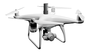
It works on the DaaS (Drone as a service) model, providing data collection services using drones with their further "turnkey" analysis.


Fill out the form below and we will contact you as soon as possible.

Fill out the form below and we will contact you as soon as possible.

Fill out the form below and we will contact you as soon as possible.

Fill out the form below and we will contact you as soon as possible.

Fill out the form below and we will contact you as soon as possible.

Fill out the form below and we will contact you as soon as possible.
office
control
control

to the Skyeer AI platform
Leave a request, our managers will respond as quickly as possible during working hours.
NPP Ruppur (Bangladesh)
Automatic determination of areas of necessary attention, planning of work with decrease in labor costs, improvement of production indicators in the monitoring stage.
Mission:
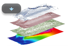
Analysis of various types of geospatial monitoring for all stages of construction.
Work done:
Space survey, UAV survey, GLS (ground laser scanning), creation of project models. Analytics of the received data.
Result:
Report on the applicability of technologies at various stages of construction for functional customers, economic justification for the applied monitoring tools.
Mission:
Development of an algorithm for automatic analytics of intra-quarry roads.
Work done:
Development of a module for automatic analysis of the state of intra-quarry roads.
Result:
Automatic determination of areas of necessary attention, planning of work with decrease in labor costs, improvement of production indicators in the monitoring stage.
Mission:
Regular monitoring of construction process.
Work done:
Scope of done works regular monitoring, management of contractors, construction and geodetic control data.
Result:
Monitoring data on a weekly basis in the Skyeer platform with all the available functionality of the software solution.
Mission:
Get the maximum polygon metrics from the original UAV survey.
Work done:
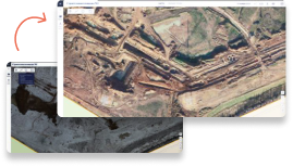
Assessment of the landfill, area, compliance with cadastral boundaries, elevations marks, residual capacity.
Result:
3D model of the object was created, the necessary analytics was provided in the Skyeer platform.
Scanned area: 3500 He
Mission:
Topographic plan, data for projection..
Work done:
Combined UAV survey and classical geodesy.
Result:
Topographic plan, orthophoto, elevation map. The data is provided in the Skyeer platform with the ability to export additional elevations and site parameters to the design software.
Scanned area: 58 000 He
Mission:
Field development control.
Work done:
Monitoring of field development, sites, access roads.
Result:
The Skyeer platform provides orthomosaics, digital elevation maps, clouds of points: each of the sites in the local coordinate system.
Fill out the form below and we will contact you as soon as possible.


Municipal district Arbat,
Novinsky, 11, floor/room 3/1 room 22
Moscow, 121099
TIN 7714762021

Заполните форму ниже и мы свяжемся с вами в ближайшее рабочее время.
Заполните форму ниже и мы свяжемся с вами в ближайшее рабочее время.
Заполните форму ниже и мы свяжемся с вами в ближайшее рабочее время.
Заполните форму ниже и мы свяжемся с вами в ближайшее рабочее время.
Заполните форму ниже и мы свяжемся с вами в ближайшее рабочее время.
Заполните форму ниже и мы свяжемся с вами в ближайшее рабочее время.
к AI-платформе Skyeer
Оставьте заявку, наши менеджеры отреагируют максимально быстро в рабочее время.
Заполните форму и получите презентацию через пару минут.
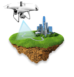
Find out how to set up full-cycle remote monitoring with Skyeer. A combination of 4 technologies opens up a horizon of possibilities - from automatic surveying and data processing to a high-precision 3D-model and automatic analytics.
Fill out the form and get a presentation in a couple of minutes.
Отправьте заявку, менеджер свяжется с вами в ближайшее время по указанным данным.
Отправьте заявку, менеджер свяжется с вами в ближайшее время по указанным данным.
Отправьте заявку, менеджер свяжется с вами в ближайшее время по указанным данным.
Отправьте заявку, менеджер свяжется с вами в ближайшее время по указанным данным.


Заполните форму ниже и мы свяжемся с вами в ближайшее рабочее время.
Сonsult
Leave your message in the form below, we will contact you as soon as possible.
We are ready to discuss your project. Fill out the form below and receive a commercial offer.
We are ready to discuss your project. Fill out the form below and receive a commercial offer.
We are ready to discuss your project. Fill out the form below and receive a commercial offer.
We are ready to discuss your project. Fill out the form below and receive a commercial offer.