


В 10 раз быстрее классической геодезии

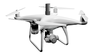
DRONES

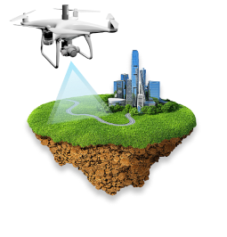
Удаленный мониторинг
объектов строительства, карьеров, полигонов ТБО
объектов строительства, карьеров, полигонов ТБО

100%
объективные данные
объективные данные

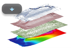
Цифровой двойник объекта

DAAS
AI spatial data platform
for earthworks, construction, mining & stockpiles
we turn your drone data into
business insights
for earthworks, construction, mining & stockpiles
we turn your drone data into
business insights
AI PLATFORM
100% unbiased data
Digital twin of your project
10х faster than classical geodetic survey


Skyeer – leading software for geospatial data analysis
Skyeer – leading software for geospatial data analysis
Skyeer — integrated IT company, developer of an analytics platform based on survey data from unmanned aerial vehicles, working and design documentation in 2D/3D formats.
It works on the DaaS (Drone as a service) model, providing data collection services using drones with their further «turnkey» analysis.
It works on the DaaS (Drone as a service) model, providing data collection services using drones with their further «turnkey» analysis.
About
Clients use Skyeer after pilot projects
95%
Hectares analysed with Skyeer
1 000 000
Projects completed with Skyeer
500+


Turnkey solution for remote control of your construction site
Solution for monitoring the progress of work in a quarry that prevents technical disasters
Digitalization of landfills
Full control of stockpile straight from your office workplace
Variety of tasks
Aerial photography
The most popular type of aerial monitoring. Used in 90% of cases.
Aerial survey using laser scanner
Ideal for creating a 3D terrain model with complex vegetation.
Ground laser scanning
It is used to create high-precision models of buildings and structures. Suitable for BIM models.
Panoramas 360°
They are able to replace stationary video cameras at any point of the facility without laying network infrastructure.
Topographic plan
Combined shooting by the classical and unmanned method can provide up to 10 times more data.
Regular UAV monitoring
Skyer will provide objective data to all participants from designers to top management.
We have all the necessary resources to perform any task of your business.


Get a commercial offer
For the service «Aerial Photography».
Fill out the form below and we will contact you as soon as possible.
Fill out the form below and we will contact you as soon as possible.
Get a commercial offer
For the service «Aerial survey using laser scanner».
Fill out the form below and we will contact you as soon as possible.
Fill out the form below and we will contact you as soon as possible.
Get a commercial offer
For the service «Ground laser scanning».
Fill out the form below and we will contact you as soon as possible.
Fill out the form below and we will contact you as soon as possible.
Get a commercial offer
For the service «Panoramas 360°».
Fill out the form below and we will contact you as soon as possible.
Fill out the form below and we will contact you as soon as possible.
Get a commercial offer
For the service «Topographic plan».
Fill out the form below and we will contact you as soon as possible.
Fill out the form below and we will contact you as soon as possible.
Get a commercial offer
For the service «Regular UAV monitoring».
Fill out the form below and we will contact you as soon as possible.
Fill out the form below and we will contact you as soon as possible.
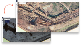
AI-platform Skyeer for data visualization
We developed a GIS platform for data visualization that provides 100% objective data for all participants in the construction or mining process.
investors
project office
mine surveyor service
subcontractors
top-management
financial control
geodetic service
construction control


Get demo access
to the Skyeer AI platform
to the Skyeer AI platform
You will be able to test the system, see how the monitoring of the dynamics of construction works for a specific period works, compare periods, view 360 Panoramas and much more.
Leave a request, our managers will respond as quickly as possible during working hours.
Leave a request, our managers will respond as quickly as possible during working hours.
Success projects
We have scaned over 1 000 000 He all over the world. Here are some projects that we are proud of.

King Khalid International Airport
07
06
05
04
03
02
01
Skyeer brings the future closer
We know how to organize fully autonomous monitoring from a high-precision 3D model to automatic analytics. For any industry. Right on time. On an object of any complexity and remoteness.
Implement the technologies of the future now. Get a presentation of the possibilities. We're ready to start.
Implement the technologies of the future now. Get a presentation of the possibilities. We're ready to start.
Reviews
Here's what customers say about the experience of using Skyeer.

«In the department, we use for the control of the CMP for landscaping: an operational calculation of the volumes of materials used, for example, measuring the areas of the laid lawn and asphalt. In Skyeer, using an orthophotoplane, it is possible to measure the areas of stacked materials on the current date. Understand the progress and the remaining amount of work. Assess the sufficiency of materials in the warehouse for the production of works. Check the compliance of the work carried out with the plan.»
Ivan Shanin, Department of Construction Management
«The Skyeer platform helps a lot.
We track the actual status of the CMP: by underground networks; buildings and structures; foundations and metal structures; aboveground pipelines.
When planning, we quickly get, for example, the actual distance between objects. We determine the correspondence of the actual location of the objects to the master plan. We clarify the marks on the ground: both actual and design. We use materials from Skyeer in presentation materials to work with the Customer and the general contractor.»
Andrey Sychev, Design Management
«We have the most practical tasks on the site. In our work we use for the following tasks:
1. Calculation of volumetric and quantitative indicators for the object.
2. Quick and accurate search for the location of the object by coordinates from the drawing.
3. The ability to scroll through the history of events in case of investigation of controversial situations.
4. Thanks to the superimposed master plan and other drawings, it is easy to find out the title or design number of the object observed on the site.
5. Using screenshots from the system in working communication with augmented sketches.
6. There is an opportunity to use the resource from a smartphone right on the site.»
Vladimir Usatov, Construction Organization
INDUCTRIAL CONSTUCTION
INDUCTRIAL CONSTUCTION
INDUCTRIAL CONSTUCTION
«We receive data in Skyeer every week, use it to update data on storage areas, count available and occupied storage areas, form storage schemes, and accurately determine the storage location of specific materials and equipment. It is easier to explain to colleagues where it is necessary to pick up the cargo.»
Kirill Bezruchko, Warehouse Logistics Management
«We use Skyeer 1 time a month to update data on storage areas, count available and filled storage areas, and for planning storage schemes.»
Ruslan Nigmatullin, Stockpiles
STOCKPILES
STOCKPILES
ESG-technology
Autonomous monitoring uses fully electric equipment, has minimal noise level and environmental impact. These are essential arguments for mass implementation, including in the agro-industrial sector. The implementation of the solution is effective for companies applying for a high ESG-rating.
The implementation of the solution is effective for companies applying for a high ESG rating.


Explore all Skyeer options for your needs today
Send us request, we will contact you and advise which Skyeer resources will be useful for your project.
Site assessment with a drone
Relief construction of complex terrain
Regular monitoring
Supervising and expert reports
info@skyeermap.com
LTD «Skyeer IT»
Meydan Free Zone, Meydan Rd, Nad Al Sheba 1, Dubai, UAE
Meydan Free Zone, Meydan Rd, Nad Al Sheba 1, Dubai, UAE